
When you’re standing at a trailhead with 50 miles of wilderness ahead, the last thing you want is to fight with an overloaded navigation app cluttered with features you’ll never use. I’ve been there – fumbling through menus while daylight fades, watching my battery drain as some app tries to convince me to share my summit photo on social media. That’s exactly the frustration that led two former Gaia GPS founders to build something different.
GoatMaps isn’t trying to be everything to everyone. It’s a mapping and navigation tool that does one thing exceptionally well: helps you find your way in the backcountry without the bloat. And after testing it against the competition, I can tell you it might just become your new favorite trail companion.
What Is GoatMaps? Understanding the Basics
GoatMaps is a GPS mapping and navigation app designed specifically for outdoor adventurers who spend time beyond the end of maintained trails. Created by Anna Hentzel-Johnson and Jesse Crocker – two of the original founders of Gaia GPS – this iOS and Mac app launched in fall 2024 with a refreshingly simple philosophy: focus on maps, route planning, and navigation, nothing else.
You won’t find weather widgets, social media feeds, or AI-generated trail descriptions here. What you will find is a lightning-fast app that opens directly to your map, downloads offline maps in the background while you grab coffee in town, and provides industry-leading cartography that’s actually readable when you’re exhausted at mile 20.
The name itself tells you everything about the app’s ethos. Mountain goats navigate steep, technical terrain with precision and confidence – exactly what backcountry travelers need from their navigation tools. Plus, co-founder Jesse Crocker’s trail name on his 2009 Pacific Crest Trail thru-hike was “Mountain Goat,” making this a personal nod to the experiences that shaped the app’s development.
Key Features That Set GoatMaps Apart
Background Map Downloads: A Game-Changer for Thru-Hikers
Here’s something you probably didn’t realize was missing from your life until now: the ability to download maps without babysitting your phone. Most navigation apps require you to keep them open while maps download, which means you’re stuck waiting instead of resupplying, eating, or showering during your precious town time.
GoatMaps downloads maps in the background. Start the download, close the app, and go live your life. When you’re ready to hit the trail again, your maps are waiting. For thru-hikers juggling limited time in trail towns, this feature alone is worth the subscription price.
Custom Slope Angle Shading: Find Your Perfect Campsite
Ever pushed on past a decent campsite hoping for something better, only to discover the next five miles are nothing but steep sidehills? GoatMaps’ custom slope angle shading solves this problem elegantly. You can quickly identify flat areas along your route where tent platforms might exist, helping you make informed decisions about when to call it a day.
This feature isn’t just for camping. Skiers and winter travelers use slope angle shading for avalanche terrain assessment, while route planners can identify challenging sections before they encounter them.
Instant Distance and Elevation Profiles
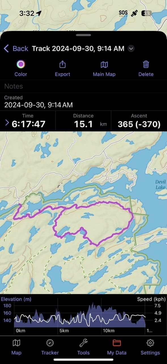
Tap two points on the map – any two points – and GoatMaps instantly generates the actual walking distance and detailed elevation profile between them. No more guessing whether that “shortcut” actually saves miles or just dumps you into a nasty bushwhack. The app calculates distance with impressive accuracy, thanks to co-founder Anna Hentzel-Johnson’s mathematical background and years of work refining these algorithms.
Advanced Route Planning Tools
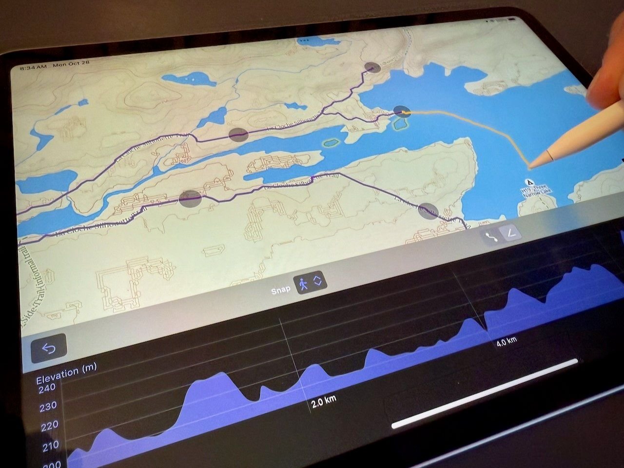
The route planner combines three different modes seamlessly: snap-to-trail for following established paths, point-to-point for covering open terrain, and freehand drawing for complete creative control. You can mix and match these approaches within a single route, name and color-code different segments, and view elevation profiles even while offline.
This flexibility makes GoatMaps perfect for planning complex trips that combine trail hiking, cross-country travel, and maybe a little creative route-finding. The interface is intuitive enough that you won’t need to watch tutorial videos just to import a GPX file or create a waypoint.
Top-Quality Cartography
The base topographic map in GoatMaps was designed from scratch by an industry-leading cartographer specifically for readability. Unlike many apps that simply license existing maps, GoatMaps created custom cartography optimized for both feet and meters, ensuring clarity whether you’re navigating in the American Rockies or the Swiss Alps.
Multiple map layers are available, including satellite imagery (with weekly updates from Sentinel), public land ownership maps for the USA, private land ownership data, and the aforementioned slope angle shading with customizable parameters.
Watch Goat Maps in Action
For a visual walkthrough of creating routes in GoatMaps, check out this tutorial:
Create A Route in Goat Maps Tutorial – Watch on YouTube
For comprehensive comparisons with other hiking apps:
Best Hiking Apps Compared – Watch on YouTube
GoatMaps Review: Real-World Performance
What Works Exceptionally Well
Speed and Reliability: The app opens instantly to your map. No splash screens, no loading delays, just your location and the terrain around you. Moving around the map is responsive and smooth, even with multiple layers enabled.
Clean Interface: Every feature serves a purpose. There’s no feature bloat, no confusing menus buried six levels deep, no constant notifications trying to get you to engage with the app’s “community.” It’s refreshingly focused.
Offline Performance: Once maps are downloaded, the app performs flawlessly without cell service. GPS positioning is accurate, and all planning tools work offline, including elevation profiles and distance measurements.
Mac Compatibility: Planning routes on a bigger screen makes everything easier. GoatMaps offers full offline map support on Mac, allowing you to design complex routes at home and sync them to your phone before heading out.
Where GoatMaps Still Has Room to Grow
Limited Trail Database: Unlike AllTrails or Wikiloc, GoatMaps doesn’t have a massive database of pre-existing routes to browse. You can import GPX files from other sources, but if you’re looking for trail discovery features to find new hikes, you’ll need to supplement with another app.
iOS and Mac Only: Android users are out of luck for now, though a web version is in development. If you’re not in the Apple ecosystem, you’ll need to wait.
No Guidebook Features: Don’t expect turn-by-turn directions to water sources or crowd-sourced comments about which campsites have the best views. That’s not what GoatMaps is trying to do – but it means thru-hikers will likely still use FarOut alongside it for waypoint-specific information.
Premium Features Behind Paywall: While free users can access basic topo and satellite maps, the good stuff – offline maps, advanced route planning, premium overlays – requires a paid membership at $29.99 per year.
Shop Outdoor Navigation Gear on Amazon
GoatMaps vs Gaia GPS: Which Navigation App Wins?
This comparison matters because both apps share DNA – the GoatMaps founders helped create Gaia GPS before it was acquired by Outside, Inc. Here’s how they stack up:
User Interface and Experience
GoatMaps: Minimalist, fast, focused. The app opens instantly to your map with zero friction.
Gaia GPS: More features but cluttered interface. Many users complain about the recent addition of social media features they didn’t want.
Map Quality and Layers
GoatMaps: Custom cartography designed for readability, with weekly satellite updates and clean public/private land ownership layers.
Gaia GPS: More map layer options overall, but lost the beloved National Geographic Trail Illustrated Maps that were a key selling point. The remaining base maps are serviceable but not exceptional.
Route Planning
GoatMaps: Excellent mobile-optimized route planning with snap-to-trail, point-to-point, and freehand modes. Intuitive and fast.
Gaia GPS: Solid route planning capabilities with more advanced features, but the interface can feel clunky. Better than CalTopo for mobile planning, but less elegant than GoatMaps.
Price
GoatMaps: $29.99/year with a 7-day free trial.
Gaia GPS: $60/year (prices have increased significantly since Outside acquired the app).
Offline Maps
GoatMaps: Background downloading lets you set it and forget it – a huge advantage for hikers in trail towns.
Gaia GPS: Requires keeping the app open while maps download, which is inconvenient.
The Verdict
For most hikers who want reliable backcountry navigation without complexity, GoatMaps offers better value and user experience. Gaia GPS still has an edge if you need access to dozens of specialized map layers or prefer a feature-rich environment, but you’ll pay twice as much for the privilege.
One Reddit user summed it up perfectly: “Gaia has the better basemap but Goat Maps is the better app.” The consensus among early adopters is that GoatMaps delivers what matters most – fast, reliable navigation – at half the price.
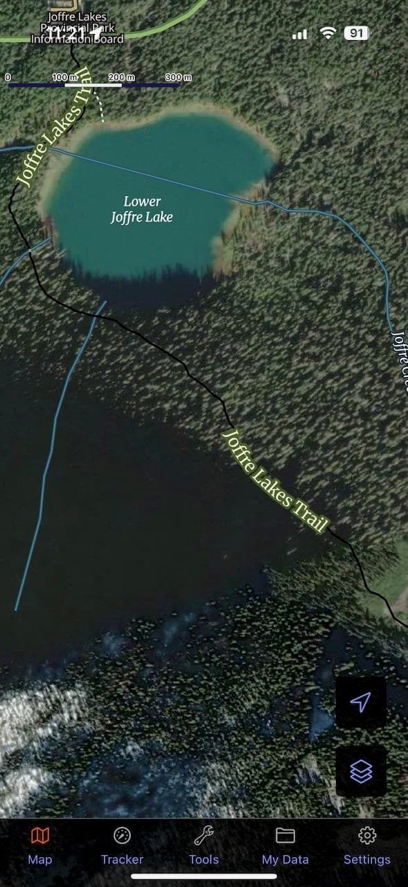
GoatMaps Alternative Options: Comparing Other Outdoor Navigation Apps
AllTrails: Best for Day Hiking Discovery
Price: Free (limited features) or $36/year for AllTrails+
AllTrails excels at helping you discover popular day hikes with user reviews, recent trail conditions, and photos. It’s perfect for casual hikers who want vetted routes near them. However, it’s less useful for multiday trips, custom routes, or technical navigation. The interface is beginner-friendly, making it ideal if you’re new to hiking apps.
Best for: Finding and navigating well-established day hikes with lots of user feedback.
Browse Trail Maps & Guides on Amazon
CalTopo: Best for Advanced Route Planning
Price: Free (basic) or $20-$100/year depending on features
CalTopo is the professional-grade planning tool for serious backcountry travelers. It offers advanced mapping layers like slope shading, fire history, and custom overlays. The desktop interface is powerful but has a steep learning curve. The mobile app exists but feels clunky compared to dedicated navigation apps.
Best for: Building complex custom routes at home, especially for cross-country travel. Many users plan routes in CalTopo, then import them into GoatMaps or Avenza for field navigation.
Related: Best hiking GPS devices and navigation tools
FarOut: Best for Thru-Hiking Long Trails
Price: $15/month, $96/year, or purchase individual trail guides
FarOut (formerly Guthook) is the undisputed champion for thru-hiking established long-distance trails like the PCT, AT, and CDT. It provides waypoint-based navigation with crowd-sourced comments about water sources, campsites, and trail conditions. However, it’s limited to specific trails in its database and doesn’t offer custom route planning.
Best for: Thru-hiking major long-distance trails where you want detailed waypoint information and real-time updates from other hikers.
OnX Backcountry: Best for Public Land Navigation
Price: Around $30-40/year (pricing varies by region)
OnX specializes in public and private land boundaries, making it invaluable for hunters, dispersed campers, and anyone navigating complex land ownership patterns. The app includes standard hiking features but really shines when you need to know exactly where public land begins and ends.
Best for: Hunting, dispersed camping, and activities where land ownership information is critical.
Wikiloc: Best Free Alternative with Offline Maps
Price: Free (with offline maps!) or $20/year for premium
Wikiloc offers offline maps in the free version – a rare perk – and boasts over 74 million user-generated routes worldwide. It’s excellent for finding obscure trails, especially internationally. However, the massive database means you’ll need to sift through duplicate or low-quality routes.
Best for: Budget-conscious hikers and international travel where mainstream apps have limited coverage.
Outdoor Maps & Navigation for Hiking: Essential Features Explained
Why Offline Maps Matter
Cell service in the backcountry is unreliable at best and nonexistent at worst. Any serious hiking navigation app must allow you to download maps for offline use. Your phone’s GPS receiver works independently of cell service, so you can see your exact location on downloaded maps even in the most remote areas.
GoatMaps handles offline maps exceptionally well, with background downloading and the ability to save multiple map types (topo, satellite, overlays) for the same area. Free apps often restrict offline maps or limit storage, making paid subscriptions worthwhile for frequent backcountry travelers.
Understanding GPS Accuracy
Here’s a dirty secret about hiking apps: they all use your phone’s built-in GPS, which means accuracy is largely identical across apps. When Jesse Crocker says “lots of other apps make claims about track recording accuracy – they are all bullshit,” he’s telling the truth. iOS handles GPS positioning; the app just displays it.
Where apps do differ is in calculating distance and elevation gain from GPS data. GPS signals have inherent errors, and distinguishing real elevation changes from GPS noise is mathematically complex. GoatMaps’ advantage comes from Anna Hentzel-Johnson’s mathematical expertise and years of algorithm refinement, resulting in more accurate statistics than competitors.
Import and Export Capabilities
The ability to import GPX files means you can plan routes in one app and navigate them in another. GoatMaps makes this seamless, supporting standard GPX format for both import and export. This interoperability is crucial for serious hikers who might plan complex routes in CalTopo but prefer navigating with GoatMaps’ cleaner interface.
Battery Life Considerations
Navigation apps drain batteries quickly because they constantly use GPS and display your screen. To maximize battery life:
- Download maps before entering the field
- Use airplane mode to prevent cell signal searching
- Reduce screen brightness
- Consider carrying a portable battery pack (essential for multiday trips)
- Enable the app’s battery-saving mode if available
Shop Portable Battery Packs for Hiking on Amazon
GoatMaps Pricing: Free vs Premium Membership
Free Features
GoatMaps offers surprisingly robust free functionality:
- View topographic maps (feet and meters)
- Satellite imagery access
- Hybrid map views
- Public land ownership maps for USA
- Basic slope angle shading
- Track recording
- Waypoint creation
- Distance measurement tools
- Share data with friends
Premium Membership Features ($29.99/year)
The paid membership unlocks:
- Offline map downloads (the most critical feature for backcountry use)
- Weekly updating satellite imagery from Sentinel with “Most Recent” and “Cloud Free” options
- Private land ownership maps for the USA with regular updates
- Advanced route planning with snap-to-trail, freehand, and point-to-point modes
- Premium overlays (expanding monthly)
- Background map downloading
- Unlimited map storage
Is the Premium Membership Worth It?
For $29.99 per year – less than three fancy coffees per month – you get offline maps and advanced route planning. That’s half the cost of Gaia GPS ($60/year) and competitive with CalTopo’s mobile plan ($20/year, though CalTopo’s mobile experience is less polished).
If you hike regularly in areas without cell service (which should be most backcountry trips), the premium membership pays for itself instantly. The 7-day free trial lets you test all features before committing, which is more than enough time to download maps for a weekend trip and evaluate performance in the field.
How to Get Started with GoatMaps
Download and Installation
- Visit the GoatMaps website or App Store
- Download the iOS app (iPhone or iPad) or Mac app
- Create a free account
- Start the 7-day premium trial to test all features
Your First Route
- Open the app and grant location permissions
- Search for your destination or browse the map
- Tap the route planning icon
- Choose your planning mode (snap-to-trail, point-to-point, or freehand)
- Create your route by tapping waypoints or drawing
- Name your route and assign it a color
- View the elevation profile
- Download offline maps for the area (requires premium)
Best Practices for Trail Navigation
- Download maps ahead of time while you have WiFi
- Create waypoints for critical locations (water sources, campsites, trail junctions)
- Share your route with someone not on the trip for safety
- Carry backup navigation (paper map and compass, or a dedicated GPS device)
- Monitor battery life and use airplane mode to conserve power
- Test the app on a short day hike before relying on it for multiday trips
Learn more: Essential backpacking gear and planning tips

Frequently Asked Questions
Can I use GoatMaps without cell service?
Absolutely. Once you’ve downloaded offline maps (premium feature), GoatMaps works perfectly without cell service. Your phone’s GPS receiver operates independently of cellular networks, so you’ll see your exact location on downloaded maps even in remote wilderness areas.
Does GoatMaps work on Android?
Not yet. GoatMaps currently supports iOS (iPhone and iPad) and Mac only. A web version is in development for spring 2026, but there’s no announced timeline for Android support.
How does GoatMaps compare to Gaia GPS?
GoatMaps is faster, cleaner, and half the price of Gaia GPS ($29.99 vs $60/year). It offers background map downloading, superior cartography, and a more intuitive interface. Gaia has more map layer options and a larger user base, but many users are migrating to GoatMaps for its simplicity and better value.
Can I import my routes from other apps?
Yes. GoatMaps supports standard GPX file import, allowing you to bring in routes created in CalTopo, Gaia, AllTrails, or any other app that exports GPX format. This makes it easy to plan routes elsewhere and navigate them in GoatMaps.
Will GoatMaps replace FarOut for thru-hiking?
No, and it’s not trying to. GoatMaps excels at mapping and navigation but doesn’t provide the waypoint-specific information (water sources, campsites, town services) that makes FarOut essential for thru-hiking. The founders recommend using both apps together – FarOut for guidebook information and GoatMaps for detailed mapping.
How accurate is the elevation data?
Very accurate. Co-founder Anna Hentzel-Johnson has a mathematics degree and has spent years refining the algorithms that calculate distance and elevation gain from GPS data. While all GPS has inherent errors, GoatMaps does an exceptional job of filtering noise and providing reliable statistics.
Can I share routes with friends who don’t have GoatMaps?
Yes. Routes can be exported as GPX files and shared via any method (email, text, cloud storage). Recipients can import them into their preferred navigation app. GoatMaps also allows direct sharing with other GoatMaps users through the app.
Does GoatMaps show private property boundaries?
Premium members have access to private land ownership maps for the USA, updated regularly. This feature helps you avoid trespassing and identify public land access points. The free version includes public land ownership maps but not private property details.
The Bottom Line: Is GoatMaps Right for You?
GoatMaps delivers exactly what its name promises: maps for people who navigate like mountain goats – with precision, confidence, and no unnecessary baggage. It’s not perfect, and it’s not trying to be everything to everyone. But for hikers, backpackers, and backcountry travelers who value speed, simplicity, and reliable navigation, it might just be the GOAT.
Choose GoatMaps if you want:
- Fast, responsive navigation without feature bloat
- Background map downloading for convenient offline access
- Custom route planning with intuitive tools
- High-quality, readable cartography
- Excellent value at half the cost of Gaia GPS
- Clean interface focused solely on navigation
Look elsewhere if you need:
- Android compatibility (not available yet)
- Extensive trail discovery features
- Dozens of specialized map layers
- Waypoint-based navigation for specific long trails
- Social features and community aspects
At $29.99 per year with a 7-day free trial, there’s virtually no risk in testing GoatMaps for yourself. Download it before your next trip, cache some maps, and see if the combination of speed, simplicity, and solid navigation tools works for your hiking style.
The founders built the app they wanted to use themselves, informed by years of experience creating Gaia GPS and thousands of miles on trail. That authenticity shows in every design decision. Sometimes the greatest of all time isn’t the app with the most features – it’s the one that nails the fundamentals and gets out of your way so you can focus on the trail ahead.
Shop Complete Navigation Kits on Amazon
Related Reading:
- Best Rock Climbing Shoes for Outdoor Adventures
- Top Hiking Boots: Complete Buyer’s Guide
- Best Bug Out Bags for Emergency Preparedness
- Essential Winter Camping Gear You Need

Brent Hillyer is a trusted outdoor writer, camping and hiking gear reviewer, and trail expert with 17+ years of hands-on experience. Since 2008, he has worked in the outdoor industry testing gear, exploring trails, and helping readers choose reliable equipment for camping, backpacking, and hiking adventures. At TheOutdoorChamp, Brent reviews camping gear using the same standards he applies in the field.